
What were the achievements and failures of Jefferson’s presidency?
In 1803, President Thomas Jefferson was presented an offer that he could not refuse: to double the territory of the United States, including the commercially important port of New Orleans, for just under $12 million. The Louisiana Purchase increased the physical territory of the United States by 828,000 square miles. The land stretched along the Mississippi River, from New Orleans up to what is now the Canadian border, and westward across the Rocky Mountains. But was the land fit for farming? And was there a passable land route across the continent to the Pacific Ocean? To obtain this knowledge, the president outfitted a company of men to follow the mighty Missouri River on its northwestern course through the center of the North American continent. The Corps of Discovery, led by Captain Meriwether Lewis and his Second Lieutenant, William Clark, charted previously unknown mountain ranges, such as the Rockies, encountered many Native American peoples, and meticulously recorded their discoveries of new species of plants and animals. The journals kept by Lewis and Clark, two entries from which are included here, are a treasure trove not only for historians but also for those who study animal biology, geography, as well as Native American culture.
DOCUMENTS
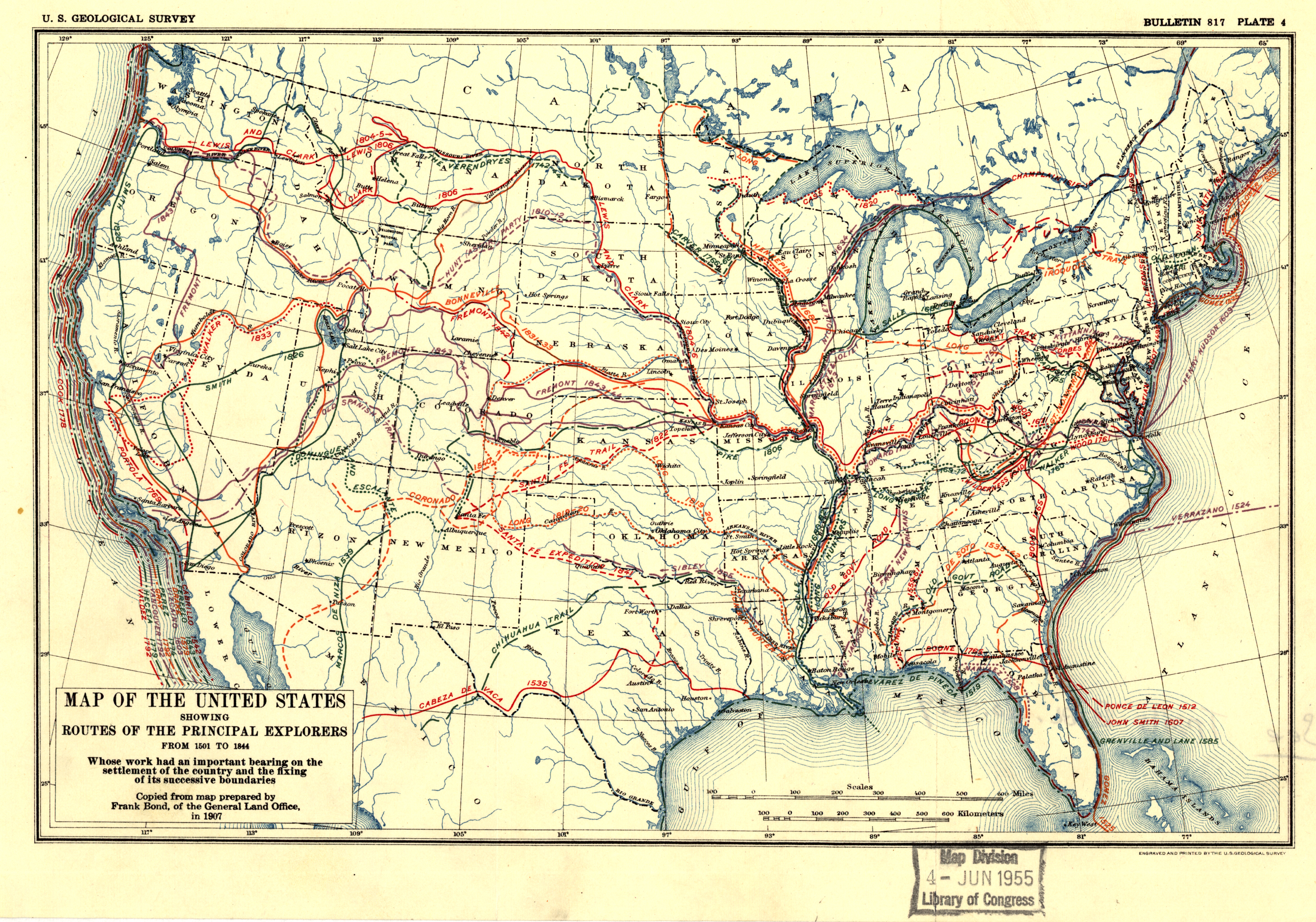
Document 1 sets the stage with a map of the journeys of the Corps of Discovery.
Document 2 includes two actual entries from the journals of Lewis and Clark, one from November 1805 and the other from March 1806. As primary sources, the journals of Lewis and Clark are rich with details about the time period, the places, and the thinking of the men who wrote them.
INSTRUCTIONS
1. Read the textbook Chapters 8 through 10.
2. Look at Document 1 and read the two entries for Document 2, with special attention to
the image and caption in the entry from March 1806.
3. Answer the questions that follow below (Questions to Answer in the Discussion Board) by Saturday by 11:59pm. You can post your comments to other students until Sunday by 11:59pm. Review the Welcome Message for more info on discussion requirements. Be sure to label your answers.
4. The discussion should reflect your own words. I use software to detect plagiarism, so do your own work and if you use ANY information from the internet it is better to be safe than sorry, so cite it. If you use the internet for help, with few exceptions like Wikipedia.org, questionable sources can be avoided by searching on reputable websites, especially those that end in .edu, .org or .gov. All other websites should be carefully considered and the information critically evaluated and questioned.
QUESTIONS TO ANSWER IN THE DISCUSSION BOARD
1) What were the achievements and failures of Jefferson’s presidency?
2) Explain how the drawing and passage in Documents 1 and 2 serve as evidence of the scientific purpose President Jefferson had in mind for Lewis and Clark’s journey.
3) Look at the Map (Document 1). What is an important piece of information that the map offered explorers and travelers at the time?
4) What does the following passage from Document 2 tell us about the relationship Lewis and Clark had with Native Americans: “they gave us to eate Some fish, and Sold us, fish . . . roots three dogs and 2 otter skins for which we gave fish hooks principally of which they were verry fond”?
Document 1
(Links to an external site.)Links to an external site.Source – Map of Principal Explorers’ Routes (1814): Library of Congress
Document 2
Meriwether Lewis and William Clark, Journals of the Lewis and Clark Expedition, [Clark: Lewis and Clark make the Pacific Ocean] November 7, 1805
[Clark] November 7th Thursday 1805
A cloudy fogey morning, a little rain. Set out at 8 oClock proceeded on 2.5 miles on the Std Side under a high hill. Steep assent 1.5 miles and on the high Land on the Std. Side. Steep assent 1 mile on the Std. Sid high hill a thick fog. Can’t See across the Riv Opposite the lower pt. of an Isd.
West 2 miles on the Stard Side under a high hill and rockey 1 mile to the head of an Island Close under the Stard Side, Sept. by a narrow Chanel. 2 Canoes of Indians met us, and returnd. With us. A Island in the middle of the river, we followed those Inds. On the North Side of the Island thro a narrow Chanel to their village on the Stard. Side of 4 houses, they gave fish to eate, and Sold us fish Salmon trout, some Wapto roots and 3 dogs, the language of thoses people have a Similarity with those above. The women ware a kind of Strand made of the fur cedar bark but Soft in place of a tite pice of leather as worn by the women above, the men have nothing except a robe about them, they are badly made and use fiew ornements.
The womens petticoat is about 15 inches long made of arber vita or the white Cedar bark wove into a String and hanging down in tossles and tied So as to cover from their hips as low as the petticoat will reach and only Covers them when Standing. As in any other position the Tosels Separate. Those people Sold us otter Skins for fish hooks of which they wer fond.
We delayed 1.5 hour and Set out the tide being up & in the river So Cut with Islands we got an Indian to pilot us into the main chanel one of our Canoes Seperated from us this morning in the fot- great numbers of water fowls of every description common to this river.
15 miles to a white tree in a Stard. Bend under a high hill passed Several marshey Isld. On the Stard. Side opposite to which & on the Stard. Side is a village of 4 houses passed Several marshey Islands on the Lard st. an Indian village on one of those Islands. They came out and traded 2 beaver skins for fishing hooks and a fiew Wapto roots. The rivr. Very wide. The beaver Skins I wish for to make a robe as the one I have is worn out. To an old village of 7 houses under the hill Stard. Side. Several Slashey Isld. On Stard Side, we called and bought a Dog & Some fish.
3 miles to a point of high land on the Stard. Side passed a Small Island on the Stard. Side the head of a large low marshy Island on the middle river about from 5 to 7 miles wide.
5 miles (lard side) to a point Stard. Side a deep bend to the Stard Side under a high mountain. Pine.
3 miles to a point on the Stard Side
[Clark]
A cloudy foggey morning Some rain. we Set out early proceeded under the Stard shore under a high rugid hills with Steep sassent the Shore boalt and rockey, the fog So thick we could not See across the river. two Canos of Indians met and returned with us to their village which is Situated on the Stard Side behind a cluster of Marshey Islands, on a narrow chanl. Of the river through which we passed to the village of 4 houses, they gave us to eate Some fish, and Sold us, fish, Wa Pa To roots three dogs and 2 otter Skins for which we gave fish hooks principally of which they were verry fond.
Those people call themselves War-ci-a-cum and Speake a language different from the nativs above with whome they trade for the Wapato roots of which they make great use of as food. Their houses differently built, raised entirely above ground eaves about 5 feed from the ground Supported and covered in the same way of those above, dores about the Same size but in the Side of the house in one Corner, one fire place and that near the opposite end; around which they have their beads raised about 4 feed from the flore which is of earth. Under their heads they Store away baskets of dried fish Berries & wappato, over the fire they hang the flesh as they take them and which they do not make immediate use. Their Canoes are of the Same form of those above. The Dress of the men differ verry little from those above. The womin altogether different, their robes are smaller, only Covering their Sholders & fallind down to near the hip- and Sometimes when it is Cole a piec of fur curiously plated and connected So as to meet around the body from the arms to the hips- (Their peticoats are of the bark of the white Cedar) “The garment which occupies the waste and thence as low as the knee before and mid leg behind, cannot properly e called a petticoat, in the common acception of the wore; it is a Tissue formed of white Cedar bark bruised or broken into Small Strans, which are interwoven in their center by means of Several cords of the Same materials which Serves as well for a girdle as to hold in place the Strans of bark which forms the tissue, and which Strans, Confined in the middle , hang with their ends pendulous from the waiste. The whoe being of Sufficent thickness when the female Stands erect to conceal those parts useally covered from familiar view, but when she stoops or places herself in any other attitudes this battery of Venus is not altogether impervious to the penetrating eyes of theamorite. This tissue is Sometims formed of little Strings of the Silk grass twisted and knotted at their ends” & c. Those Indians are low and ill Shaped all flat heads.
After delaying at this village one hour and a half we set out piloted by an Indian dressed in a salors dress, to the main Chanel of the river. The tide being in we Should have found much dificuelty in passing into the main Chanel from behind those islands (if) without a pilot, a lare marshey Island near the middle of the river near where Several Canoes Came along Side with Skins, roots fish & c. to Sell. And had a temporey residence on this Island. here we See great numbers of water fowls about those marshey Islands; here the high mountainous Countrey approaches the river on the Lard Side. Ahigh mountn. To the S W. about 20 miles, the high mountains. Courntrey Continue on the Stard Side about 14 miles below the last village and 18 miles of this day we landed at a village of the Same nation. This village is at the foot of the high hills on the Stard Side back of 2 small Islands it contains 7 indifferent houses built in the Same form as those above. here we purchased a dog Some fish, wappato roots and I purchased 2 beaver skins for the purpose of making me a roab, as the robe I have is rotten and good for nothing. opposit to this Village the high mountaneous Countrey leave the river on the Lard Side below which the river widens into a kind of Bay & is Crouded with low islands Subject to be covered by the tides- we proceeded on about 12 miles below the village under a high Mountaneous Countrey on the Stard. Side. Shore boald and rockey and Encamped under a high hill on the Stard. Side. opposit to a rock Situated half a mile from the Shore, about 50 feet high and 20 feet Diamieter. We with dificuelty found a place Clear of the tide and Sufficiently large to lie on and the only place we could bet was round Stones on which we lay our mats. Rain Continud. Moderately all day and Two Indians accompanied us from the last village, they we detected Stealing a knife and returned, our Small Canoe which got Seperated in the fog this morning joined us in the evening from a Large Island Situated nearest the Lard Side below on the high hills on that Side, the River being too wide to See either the form Shape or Size of the Islands on the Lard Side.
Great joy in camp we are in View of the Ocian, this great Pacific Octean which we have been So long anxious to See. And the roreing or noise made by the waves brakeing on the rockey shores (as I Suppose) may be heard distinctly.
Source: The Journals of Lewis and Clark, Meriwether Lewis and William Clark, 1804-1806, Project Gutenberg: http://www.gutenberg.org/files/8419/8419-h/8419-h.htm.